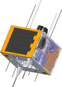
First micro satellite designed and built in Turkey: RASAT
RASAT is the second remote-sensing satellite after the launch of Turkey’s first remote
sensing satellite BiLSAT of TÜBİTAK UZAY. RASAT, having a high-resolution optical
imaging system and new modules developed by Turkish engineers, will be the first
Earth-observation satellite to be designed and manufactured in Turkey.
First micro satellite designed and built in Turkey: RASAT
RASAT has been operational since the day of launch -17th of August,2012.
RASAT is the second remote-sensing satellite after the launch of Turkey’s first remote
sensing satellite BiLSAT of TÜBİTAK UZAY. RASAT, having a high-resolution optical
imaging system and new modules developed by Turkish engineers, will be the first
Earth-observation satellite to be designed and manufactured in Turkey.
MISSION:
- To improve know-how from design phase to in-orbit commissioning phase of a satellite project gained from BiLSAT Project,
- To develop space qualified systems using currenttechnologies and gaining flight heritage bysucceeding in operating these systems in space,
- To meet the requirements of Turkey in the sense of remote sensing as much as possible,
- To investigate the current capabilities of Turkey for space technologies and to use as much as possible,
- To increase number of qualified man power in the field of satellite technologies,
- To meet the requirements of Turkish space industry through development of critical modules,
- To prove the space-based capabilities of TÜBİTAK UZAY to Turkey and the World.
For more information:http://uzay.tubitak.gov.tr/tr/uydu-uzay/rasat
TECHNICAL SPECIFICATIONS |
|
| Turkish Earth Observation Satellite | RASAT |
| Mass | 93 kg |
| Orbit | 700 km circular, sun synchronous |
| Orientation Control | 3 axis control |
| Orbit Time | 98.8 min |
| Local time on Equator | 10:30 |
| Spatial Resolution | Pankromatic: 7.5 m Multiband: 15 m |
| Expected Mission Life | 3 years |
| Spectral Resolution (μm) | 0.42 – 0.73 (Pankromatic) 1. Bant: 0.42 – 0.55 (Blue) 2. Bant: 0.55 – 0.58 (Green) 3. Bant: 0.58 – 0.73 (Red) |
| Radiometric Resolution | 8 bits |
| Revisit Time | 4 days |
| Swath Width | 30 km |
| Payloadsr |
|
| USAGE AREAS | |||
| Mapping | Disaster Monitoring | ||
|
|
Mapping of Landslide Areas |
||
| Environmental Studies | City Planing | ||
|
|
|
||