A digital elevation model is a digital model or 3D representation of a terrain′s surface created from terrain elevation data.
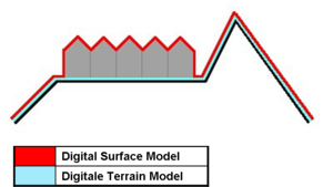
Digital Elevation models are divided into two models; Digital Terrain Models (DTM) and Digital Surface Models (DSM).
CLICK for the Accuracies of DTM/DSM products derivered from Stereo Satellite Imageries
Older times, digital elevation models were generated from digital contour maps derived from direct survey of lans surface. But nowadays, photogrammetric and remote sensing methods like stereo satellite images, sar interferometric or radargrammetry methods are more preferable.
Usage Areas:
- Extracting terrain parameters for geomorphology
- Modeling water flow for hydrology or mass movement (for example avalanches and landslides)
- Creation of relief maps
- Rendering of 3D visualizations.
- 3D flight planning
- Creation of physical models (including raised relief maps)
- Rectification of aerial photography or satellite imagery
- Reduction (terrain correction) of gravity measurements (gravimetry, physical geodesy)
- Terrain analysis in geomorphology and physical geography
- Geographic Information Systems (GIS)
- Engineering and infrastructure design
- Global positioning systems (GPS)
- Line-of-sight analysis
- Base mapping
- Flight simulation
- Precision farming and forestry
- Surface analysis
- Intelligent transportation systems (ITS)
- Auto safety / Advanced Driver Assistance Systems (ADAS)
- Archaeology
PlanetDEM - Accurate and reliable elevation data offering global Earth coverage
Planet DEM 30Plus:
Global multi-source Digital Elevation Model with 30-meter resolution processed from SRTM data (Shuttle Radar Topography Mission) that offers reliable, seamless and accurate data for the Earth’s entire land surface. 
PlanetObserver offers global elevation data suitable for many projects and applications, ranging from visualization and simulation solutions for military and commercial solutions, to web-mapping and energy projects.- PlanetDEM features:
Global: Full coverage of the planet - Corrected: Enhanced processing of multisource data
- Reliable:Assessed by major players of the Defence and Energy industry
- Off-the-shelf: Available immediately in professional file formats (GeoTiff and DTED2)
For more information follow: http://www.planetobserver.com/
PlanetObserver offers global elevation data suitable for many projects and applications, ranging from visualization
and simulation solutions for military and commercial solutions, to web-mapping and energy projects.PlanetObserver offers global elevation data suitable for many projects and applications, ranging from visualization
and simulation solutions for military and commercial solutions, to web-mapping and energy projects.PlanetObserver offers global elevation data suitable for many projects and applications, ranging from visualization
and simulation solutions for military and commercial solutions, to web-mapping and energy projects.PlanetObserver offers global elevation data suitable for many projects and applications, ranging from visualization
and simulation solutions for military and commercial solutions, to web-mapping and energy projects.